


Illustrated Geological Dictionary L–P: an illustrated reference with definitions connecting sedimentary, igneous, and metamorphic processes to paleontological evidence, stratigraphic correlation, and key events in the geological and biological history of Earth.
Alphabetical index of geological terms
The illustrated geological dictionary introduces geological terms that frequently appear in Earth science, paleontology, and sedimentary research.
A | B | C | D | E | F | G | H | I | J | K | L | M | N | O | P | Q | R | S | T | U | V | W | X | Y | Z
Introduction to the Illustrated Geological Dictionary
Illustrated Geological Dictionary L–P—this section presents geological terminology from lava and limestone to plate tectonics and pyroclastic flows, linking fundamental rock-forming processes to the sedimentary environments that preserve the history of life. Maar lakes, microbialites, and lagerstätten offer exceptional windows into ancient ecosystems, while entries on mantle convection and mid-ocean ridges place these processes in their broader geodynamic context. Each definition connects terminology to specific formations, time periods, and paleontological examples, and includes an illustration drawn from the geological and fossil record.
Keywords: geology terminology, geological vocabulary, Earth science terminology, sedimentary geology terms, geological processes, geological dictionary, paleontology
L
labradorite

Right: This is a raw, natural labradorite mineral. © Crystal Magic
Labradorite — a calcium-rich plagioclase feldspar containing 50–70% anorthite; it often displays an iridescent effect when reflecting light. Labradorite occurs as gray, gray-green, or gray-blue grains in basalts, gabbros, and anorthosites. It forms during the slow cooling of mafic magma. Because of its magmatic origin, it does not contain direct fossils, but anorthosites serve as markers of ancient crust and as analogs of lunar rocks. Examples: anorthosites of Labrador (Canada, ~660 Ma and older); Nain Plutonic Suite; Wiborg Batholith (Finland, ~1.63 Ga). Synonym: labrador feldspar.
laccolith

Right: Enchanted Rock laccolith, located between Fredericksburg and Llano, Texas (USA). © Adam Hite/The Outbound Collective
Laccolith — a mushroom-shaped or lens-like intrusion formed when viscous magma intrudes between layers of host rock: the magma uplifts the overlying strata without breaking through to the surface. Laccoliths occur at shallow depths and range in size from hundreds of meters to several kilometers. Geologists often describe them as “failed” volcanoes. The intrusion deforms and metamorphoses the surrounding sedimentary sequences, influencing fossil preservation. Classic example: Henry Mountains (Utah, USA), where intrusions uplifted Mesozoic deposits containing dinosaur tracks and marine fossils. Synonym: laccolite (obsolete).
lahar

Middle: Historic Lahar Deposits in Geopark Kutralkura, Chile. © Geodiversity Geoconservation
Right: Lahar falls near Abacan Gap, Lower Sacobia River near Mount Pinatubo, Philippines. © mtu.edu
Lahar — a rapid volcanic flow—is a type of debris flow consisting of a fluid mixture of water and pyroclastic material that moves downslope from a volcano; it is an intermediate form between a volcanic avalanche and a water flow. Lahars destroy everything in their path and can reach speeds of up to 200 km/h, making them extremely hazardous. Rapid burial in silica-rich material promotes the fossilization of organic remains, especially wood. Examples: Eocene fossilized trees in Florissant Fossil Beds and Specimen Ridge; ancient lahars in the Absaroka Volcanic Field. Synonyms: volcanic mudflow; debris flow.
lapilli

Right: Lapilli come in different colors and types, depending on the processes involved in their formation. © geologyscience | Mahmut MAT
Lapilli — small (2–64 mm) rounded or angular pyroclastic fragments, consisting of solidified lava clasts or pieces of host rock ejected during eruption. They form lapilli tuffs and breccias (lapillistone), which serve as markers of explosive volcanic events in stratigraphic sections. Rapid burial in lapilli tuffs ensures exceptional preservation of organic remains. Examples: leaf impressions in lapilli tuff of the Picture Gorge Ignimbrite (Oregon, USA); fossilization of soft feather tissues of a Pleistocene vulture in lapilli-bearing pyroclastic deposits of the Alban Hills (Italy, ~30,000 years).
late heavy bombardment

Late Heavy Bombardment — a period of intensified impact events in the Solar System (~4.1–3.8 Ga), spanning the transition from the Late Hadean to the early Eoarchean. Planetary migration of the giant planets likely destabilized the orbits of numerous small bodies, which then struck the surfaces of the inner planets. Most lunar craters formed during this interval; erosion and tectonics have erased all traces of them on Earth. Immediately after this period, the first signs of life appear (~3.85–3.5 Ga). Examples: spherule layers in the Barberton Greenstone Belt (South Africa); possible biogenic isotopic signals in Greenland rocks (~3.85 Ga). Synonym: last meteorite bombardment.
lava

Right: Pāhoehoe flowing over an older ‘a‘ā flow in 2015. © USGS.
Lava — molten silicate magma that has erupted onto the Earth’s surface, from which part of the dissolved gases has been released during eruption. Modern lavas have temperatures of about 700–1200 °C; in the Archean, when the mantle was hotter, temperatures reached 1300–1400 °C. Upon cooling at the surface, lava forms sheets of extrusive rocks, predominantly basalts and andesites. In the Archean, komatiitic and basaltic lavas are associated with the earliest stromatolites and microfossils. Examples: lava molds of trees in Hawaii (modern and Holocene); dinosaur tracks preserved between basalt flows of the Karoo Basin (~183 Ma, Early Jurassic); stromatolites in lava intervals of the Pilbara Craton (~3.5 Ga). Synonyms: molten lava; effusive lava.
Levant

Right: Public domain map of the Levant. Source: PAT/Ian Macky
Levant — in geography, the eastern Mediterranean region, including the coasts of Syria, Lebanon, Israel, Jordan, southern Turkey, Cyprus, and the Sinai Peninsula. In geology, the Levant is a tectonic segment separating the African and Arabian plates along the Dead Sea Transform (Syrian Fault System). The region contains extensive Mesozoic and Cenozoic marine and continental deposits. It represents a key corridor for hominin migration and a site of rich paleontological discoveries. Examples: Lagerstätten of Hakel and Hjoula (Lebanon, Cenomanian–Santonian) with articulated fishes; caves of Skhul, Qafzeh, and Kebara (Israel) with Homo sapiens and Neanderthals; Ubeidiya with Early Pleistocene fauna. Synonyms: Levantine region, Eastern Mediterranean.
limestone

Right: Outcrop of white limestone rock formation with steep slope in Poland near Solec Kujawski. © michal812
Limestone — a sedimentary rock composed mainly of calcite (CaCO₃) and sometimes aragonite; it forms primarily through biogenic processes from the remains of marine organisms, and, more rarely, by chemical precipitation from seawater. Types of limestone include chalk, calcarenite, coquina, and travertine; under metamorphism, limestone transforms into marble. Typically, white or gray, limestone reflects ancient shallow-marine environments and often contains abundant and diverse marine fossils ranging from the Cambrian to the present. Classic examples: Solnhofen Limestone (Germany, Jurassic) with Archaeopteryx; Cretaceous writing chalks with foraminifera, coccoliths, and marine reptiles (England, USA).
limnoglacial deposit

Right: Limnoglacial deposits in the Doda and Suru river basins. A) The photograph shows the two proglacial lakes that are formed near the front of the Durung-Drung glacier. B) The secondary lake is positioned at a proximity of merely 1 km from the Durung-Drung glacier terminus. Western Himalaya, Ladakh. © Yadav et al.
Limnoglacial deposits — a sediments that accumulate on the bottoms of lakes at glacier margins or in dead-ice environments from meltwater. They consist of sorted, typically stratified deposits ranging from gravel-sand facies to fine-grained silts and thinly laminated varved clays. These deposits serve as an important chronological record of the Late Glacial and Holocene, preserving traces of biological activity from insects, crustaceans, and nematodes, as well as pollen and organic matter. Examples: Late Pleistocene varves of Lithuania and Ontario with ichnofossils Glaciichnium and Cochlichnus; varved sequences of Sweden and Finland containing larval traces. Synonym: glaciolacustrine deposit.
lithogenesis

Right: Humid type of lithogenesis. Peat deposits (Ireland). © liamgrehan.
Lithogenesis — the set of processes involved in the formation and evolution of sedimentary rocks and associated mineral resources (coal, oil, bauxites, phosphorites). It includes weathering, transport, deposition, diagenesis, catagenesis, and, in some cases, low-grade metamorphism. Lithogenesis creates the conditions for the burial and fossilization of organic matter, thereby controlling the preservation of the paleontological record. Examples: biogenic lithogenesis of limestones with marine fossils (Solnhofen Limestone); coal-bearing formations with plant remains (Carboniferous deposits of the Donbass Coal Basin, Permian deposits of Kuzbass). Synonyms: sedimentogenesis; sedimentation.
lithology

Right: Geological model visualization. Lithology forms the backbone of stratigraphic interpretation, connecting rock description to depositional history, structural modification, and practical subsurface modeling. © Lina Jakaite
Lithology — the geological science of sedimentary rocks, their composition, structure, physical properties, and patterns of formation, including diagenesis and facies changes. This field investigates the conditions of accumulation and the evolution of sedimentary complexes. It makes extensive use of paleontological and stratigraphic data to achieve these results. Rock type determines burial conditions and fossil preservation, while fossil remains provide keys for biostratigraphy and the correlation of sections. Ultimately, these elements allow for the reconstruction of paleoenvironments. Synonym: sedimentary petrology.
lithosphere

Lithosphere — the upper solid shell of the Earth, comprising the crust and the uppermost mantle, situated above the asthenosphere. Its thickness varies from several tens to ~200 km, differing between continental and oceanic regions. Most of the lithosphere consists of crystalline materials formed during magma cooling. The lithosphere grades into the asthenosphere without a sharp boundary; movement of its plates explains fossil distribution and tectonic cycles. Examples: mesosaur remains in Permian deposits of South America and Africa (evidence for Gondwana); Glossopteris flora across all southern continents; 36‑million‑year tectonic cycles influencing Phanerozoic biodiversity.
lithospheric plate

Right: Illustration of the concept of plate tectonics, showing the Earth, whose lithosphere is broken up into large blocks called lithospheric plates.
Lithospheric plates — the largest stable blocks of the lithosphere that form the Earth’s rigid outer shell, including continental or oceanic crust together with the uppermost mantle. Plates move across the asthenosphere under the influence of mantle convection at rates of 1–10 cm per year. Geologists usually distinguish seven major plates and several minor ones. Plate interactions—subduction, extension, and collision—produce rifting and mountain building. Plate motion drives the assembly and breakup of supercontinents: for example, the breakup of Pangaea (~200–150 Ma) explains identical fossils found today on separate continents in South America and Africa.
loess

Right: These are thick loess deposits on the Chinese Loess Plateau showing changing Ice Age climate. Visible dark bands are fossil soils from warm intervals, and lighter intervals show enhanced dustiness during full ice age conditions. © Thoams Stevens
Loess — a homogeneous, non-stratified, porous rock composed of silt-sized material dominated by quartz, clay minerals, and carbonates; often containing carbonate concretions. Loess typically shows a light yellow color and belongs to loams, less commonly to sandy loams. Strong winds deposited it mainly during cold, dry phases of Pleistocene glaciations. Loess deposits are widespread at temperate latitudes in Eurasia and North America. They contain rich remains of mammoth fauna (mammoth, woolly rhinoceros, bison) and serve as a key archive of paleoclimatic change. Examples: loess sequences of Ukraine, China, and the Mississippi Valley.
lopolith

Right: The lopolith “Shivlinga” formed some 67-66 million years ago in the Cretaceous period on the Deccan Plateau. © Photos above and below by Vaibhavi Bhatt
Lopolith — a large saucer-shaped intrusive igneous body with a flat or slightly concave roof, a basin-like floor, and an underlying feeder conduit, emplaced concordantly between layers of country rock. Its diameter may reach tens of kilometers. Lopoliths have formed since the Proterozoic, mainly through the emplacement of basic (mafic) magma into sedimentary sequences of cratonic platforms. The enclosing Paleozoic–Mesozoic strata, often containing fossils, allow the dating of magmatic phases. Examples: the Bushveld Igneous Complex, the world’s largest source of platinum and chromium; the Duluth Gabbro Complex (Minnesota, USA), a classic lopolith described by Grout in the early 20th century.
M
maar

Right: View of Al Wahbah maar cut deeply into the Neoproterozoic basement and pre-existing Pleistocene scoria cones and lava flows. Arabian Peninsula, Saudi Arabia. © IUGS
Maar — a broad, low-relief volcanic crater with a floor lying below the pre-eruption surface, formed by phreatomagmatic explosions when magma interacts with water. Maars lack a cone and are surrounded by a low rim of pyroclastic deposits (<30–50 m), without lava flows. Maars often develop on plains far from other volcanic centers, and water commonly fills their craters. Lacustrine deposits in maars serve as exceptional Konservat-Lagerstätten and paleoclimatic archives: they preserve plants, insects, pollen, and varves that record climate change. Examples: Messel (Eocene, Germany, rich fauna and flora); Eifel maars (Late Pleistocene–Holocene).
mafic rock
Right: Dark-colored, coarse-grained mafic troctolite rock from the Precambrian of Wyoming, USA. © James St. John
Mafic rock — a dense igneous rock with low SiO₂ content (45–52%) and high concentrations of magnesium and iron. Its dark color derives from pyroxenes, amphiboles, olivine, and calcium-rich plagioclase. Mafic rocks include basalt, dolerite, and gabbro (IUGS classification). They form through partial melting of the mantle and constitute the foundation of oceanic crust; they dominate Archean greenstone belts and large layered Proterozoic intrusions. Example: Stillwater Complex (USA, ~2.7 Ga), with chromite- and platinum-group element–rich layers. Synonym: basic rock.
magma

Right: Volcanic eruption cross-section structure. © Tatiana Egorova
Magma — a molten mass of predominantly silicate composition containing crystals and dissolved gases, generated in the asthenosphere. Because of its lower density, magma rises upward; when emplaced in the crust, it forms intrusive rocks, and when erupted at the surface, it produces lava and volcanic rocks. Magma that has erupted but not solidified is termed “lava”. Based on composition, geologists distinguish basaltic (mafic), andesitic (intermediate), and rhyolitic (felsic) magmas. In Earth’s early history, high‑temperature ultramafic magmas predominated, reflecting the hotter Archean mantle. Examples: komatiitic lavas of greenstone belts (~3.5–2.5 Ga); basaltic magmas of mid‑ocean ridges.
magma convection

Magma convection — the process of heat exchange in molten rock within magma chambers and volcanic conduits. Hot, less dense parts of the molten material rise and sometimes break through to the surface, while cooler, denser parts sink, causing the magma to mix. This circulation leads to fractionation and chemical layering as temperature and pressure decrease. Convection produces large, layered intrusive complexes. Classic example: Skaergaard Intrusion (Greenland, ~55 Ma), where convective currents generated pronounced layering and cumulate textures in basaltic magma.
magmatic eruption

Right: Lava fountains and ash plume from Momotombo volcano. © Canal6Nicaragua
Magmatic eruption — the process of magma reaching Earth’s surface, driven by gas release during decompression of ascending magma from its chamber. Low‑viscosity basaltic magmas generate predominantly mild effusive eruptions, while viscous andesitic–rhyolitic magmas with high gas content trigger powerful explosive eruptions with pyroclastic material. In geological history, magmatic eruptions played a key role in forming flood basalts (Siberian and Deccan Traps) and calderas (Yellowstone), influencing biotic crises.
magnetite

Right: A massive chunk of iron ore, which is composed of almost pure magnetite. Kiruna, Sweden. © Sandatlas
Magnetite — a common iron oxide, magnetic iron ore, and the most magnetic mineral; an important iron ore. It is a mixed oxide of divalent and trivalent iron with admixtures of magnesium, and, more rarely, manganese, chromium, titanium, and others. Its color is black. Magnetite is attracted to a magnet but does not itself attract iron. It occurs in igneous and metamorphic rocks, ore bodies, schists, placers, and heavy mineral fractions of sands. Magnetite records remanent magnetization during lava cooling or sediment accumulation, preserving the orientation of Earth’s ancient magnetic field—evidence that helped demonstrate continental drift and plate tectonics. Synonym: magnetic iron ore.
mantle

Right: The structure of the earth has three main parts: the core, the mantle, and the crust. © mammoth memory
Mantle — the internal part of the Earth between the crust and the core (depth ~2900 km), occupying 83% of the planet’s volume. It consists of dense, refractory ultramafic rocks (peridotites, eclogites) and is hot enough to undergo slow viscous flow. The mantle is subdivided into the upper mantle (to 660 km) and the lower mantle (to 2890 km), with seismic boundaries at 410 and 660 km. With increasing depth, silicates transform into superdense high‑pressure phases with magnesium and iron oxides. The mantle serves as the source of magmas and the driving medium of plate tectonics throughout Earth’s geological history.
mantle convection

Right: Thermal convection in the mantle causes tectonic plate movement. Source: mammoth memory
Mantle convection — the slow, large‑scale movement of the mantle’s plastic material driven by gravity, heat flow from the core, and radioactive decay. Hot, less dense mantle material rises, while cooler, denser material sinks, forming convective cells. This circulation acts as the driving force of plate tectonics and volcanism. Mantle convection governed the assembly and breakup of supercontinents throughout geological history, controlling biotic migrations and biotic crises, including the Permian–Triassic and Cretaceous events.
mantle plume

Mantle plume — a narrow, ascending stream of hot mantle material that originates in a thermochemical boundary layer of low viscosity between the mantle and the outer core and rises independently of large-scale mantle convection. These plumes have base diameters ranging from tens to hundreds of kilometers and expand upward as they ascend. Scientists consider them responsible for forming flood basalts (traps), intracontinental rifts, and surface hot spots on Earth, such as the Hawaiian archipelago. Mantle plumes give rise to large igneous provinces (LIPs), which are often associated with mass extinction events.
marble

Right: Pink and white marble. © Europosters.
Marble — in geology, a metamorphic rock formed by recrystallization of sedimentary limestones and dolomites. Marble may contain impurities of quartz, graphite, serpentine, iron oxides, and other minerals that impart a wide range of colors (white, gray, green, and red). Marbles occur widely in orogenic zones such as the Appalachians and the Alps. Cambrian–Paleozoic reef structures containing stromatolites, brachiopods, and corals often serve as their protoliths. Metamorphism usually destroys fossils, but relic structures sometimes preserve them.
marginal sea

Marginal sea — a shallow pericontinental basin along an active continental margin, partly enclosed by peninsulas, island arcs, archipelagos, or submarine ridges. It connects to the ocean but experiences restricted water exchange due to barriers and reduced depth. Marginal seas form through subduction (back‑arc basins) or rifting. They reflect paleotectonic cycles (e.g., Paleogene basins of the Tethys, Miocene basins of the South China Sea) and host rich faunas of mollusks, foraminifera, and reef corals. Modern examples: Arabian Sea, Baltic Sea, Bering Sea, Beaufort Sea, Black Sea, Gulf of Mexico, Red Sea, Yellow Sea.
marlstone

Right: Marlstone interlayered with carbonate-rich layers of marly limestone. Capo Vita, Island of Elba, Italy. © Geology is the Way
Marlstone — a fine‑grained sedimentary rock of mixed clay–carbonate composition; it contains fine‑grained calcite/dolomite (35–65%) and clay (25–65%), intermediate between clay and limestone. Marlstone commonly forms from calcareous muds in marine or lacustrine lagoons, with calcareous (calcite‑rich) and dolomitic varieties. It has an earthy appearance, blocky fracture, and gray/green coloration. Thanks to its fine‑grained texture and frequent anoxic conditions, marlstone is rich in ammonites, belemnites, bivalves, and microfauna (foraminifera). Classic examples: Marlstone Rock Bed (Early Jurassic, England) with ammonites Dactylioceras; Grayson Marl (Cretaceous, Texas) with abundant marine fauna (oysters, mollusks). Synonyms: clayey limestone, mergel.
metabasalt

Right: Precambrian metabasalt greenstone at Catoctin Mountain, Maryland. © Mike Fitzpatrick
Metabasalt — a fine‑ to medium‑grained metamorphosed basalt. Its mineralogy includes actinolite, chlorite, epidote, and albite. Metabasalt forms in subduction zones, spreading centers, greenstone belts, dike complexes, and oceanic crust; under stronger metamorphism, it transforms into amphibolite. Geologically, metabasalt serves as a marker of Proterozoic–Paleozoic orogenies (Urals, Appalachians, California) and occurs in greenstone belts with biotic relics (stromatolites, graphite, graptolites). Example: Barberton Greenstone Belt (South Africa, ~3.5–3.3 Ga), where metabasalt lies adjacent to some of the earliest evidence of life (stromatolites and microfossils). Synonyms: greenstone, greenschist, uralite porphyrite.
metamorphism

Right: Metamorphism is the transformation of a rock in the solid state. © Le Comptoir Géologique
Metamorphism — the substantial transformation of rocks without melting or complete dissolution, caused by elevated temperature, pressure, and active fluids in the Earth’s crust (rarely in the upper mantle). Processes include compaction, recrystallization, and structural modification while generally preserving overall chemical composition (isochemical metamorphism). Metamorphism is widespread in Archean and Proterozoic shields as well as in Paleozoic–Mesozoic fold belts. Examples of metamorphosed rocks: granite → gneiss/schist; sandstone → quartzite; limestone → marble; shale (or mudstone/argillite) → slate → phyllite → mica schist → gneiss; basalt (or gabbro) → greenschist → amphibolite.
metasediment

Right: The metasedimentary rock of the Palm Canyon Complex in the E. Peninsular Range of Southern California. © Geologically Speaking
Metasediment — a sedimentary rock that has undergone metamorphism, altering its texture and mineralogy under high temperature and pressure. Metasediments often retain primary bedding or layering, even under strong deformation. They are typical of orogenic belts and Archean terranes. Under moderate metamorphism, microfossils and stromatolites may survive (e.g., metasediments of the Pilbara Craton, Australia, ~3.4 Ga); at higher grades, biogenic structures are destroyed. Examples: marble, metapelite, metapsammite, quartzite. Synonym: metasedimentary rock.
metasomatism

Right: Magmatic metasomatism refers to the alteration of rocks by magmas that release volatiles and fluids during cooling.
Metasomatism — a geological process that alters the chemical composition of a rock under the influence of hydrothermal fluids, magmatic gases, or pneumatolytic agents. It occurs both under deep conditions of high temperature and pressure (endogenic) and near the surface at lower temperatures. Metasomatism is responsible for the formation of many major ore and non-ore mineral deposits. It can distort or destroy fossils: recrystallization replaces shells with calcite or dolomite (as in skarns), while hydrothermal input of Si, Mg, and Fe obliterates biogenic features of stromatolites and microfossils, complicating the identification of life in Precambrian terranes. Examples: skarn, greisen, albitite, fenite, listvenite, rodingite, and serpentinite (autometasomatism).
metavolcanic rock

Right: Dark metavolcanic rock deep in the narrowest segment of the Enchanted Gorge. © SummitPost.org.
Metavolcanic rock — a metamorphic volcanic rock (lava or tephra) buried beneath other strata and subjected to high temperature and pressure during subsidence, which induces recrystallization while often preserving original volcanic textures. Metavolcanic rocks are typical of greenstone belts, marginal seas, subduction zones, and Archean–Proterozoic terranes. Their mineral assemblage includes quartz, plagioclase, amphibole, pyroxene, actinolite, epidote, and chlorite. Because of intense metamorphism, metavolcanic rocks rarely contain fossils; however, in low‑grade facies of greenstone belts, associated volcano‑sedimentary deposits may preserve some of the earliest stromatolites, microbial mats, and microfossils. Examples: metabasalt, metarhyolite, meta‑andesite, and metatuff.
meteorite crater

Right: Tenoumer Crater Ridge, deep in the Sahara, approximately 1.57 million years old (Ma). Mauritania © Giulio Aprin
Meteorite crater — a circular depression with raised rims and a deepened floor, formed by the high‑velocity impact of a meteorite; its diameter is usually 3–5 times greater than its depth, and larger craters develop a central peak. Shock features are characteristic: planar deformation structures, stishovite, and impact breccias. Impact glasses sometimes preserve microbial remains and biomarkers (example: Ries Crater, Germany). Meteorite craters record stages of intense bombardment of the early Earth (~3.8–3.5 Ga), which contributed to crustal differentiation. Examples: Vredefort (South Africa), Popigai (Russia). Synonym: impact crater.
micrite

Right: Micritic limestone near the village of Wittgendorf, Thuringian Slate Mountains. © Thomas Voigt
Micrite — a microcrystalline carbonate mud composed of calcite grains 1–4 µm in diameter; typically dark gray, dull, and homogeneous. Micrite forms the main matrix of many limestones. It originates through chemical precipitation, biogenic activity (algae), or erosion of bioclasts in quiet shallow‑marine or lacustrine environments. Micrite forms envelopes around shells and foraminifera, preserving them within reef complexes. It also contributes to stromatolites, where it records traces of microbial mats and early life (Archean Pilbara, Mesoproterozoic China). Synonym: mikrite.
microbialite
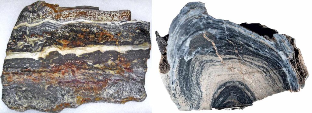
Right: Microbialite. This sample contains a fossil of microbial mats that provide evidence of the type of life on the planet’s surface 2.4 billion years ago. Muséum national d’Histoire naturelle © MNHN – A. Iatzoura
Microbialite — an organogenic carbonate sedimentary structure. It forms when microbial communities (mats) living on the floor of a water body trap and precipitate mineral particles, producing laminated or clustered films. Types include stromatolites (laminated), thrombolites (clotted), dendrolites (dendritic/branched), leiolites (amorphous/structureless), and oncolithes (spherical). Microbialites represent some of the earliest evidence of life on Earth. In the Archean, cyanobacterial mats dominated shallow seas and contributed to the accumulation of oxygen in the atmosphere. Examples: stromatolites of the Dresser Formation (Pilbara, Western Australia, ~3.48 Ga); structures of Isua (Greenland, ~3.7 Ga). Synonym: microbial laminite (for laminated forms).
microcontinent

Right: Microcontinents in the Indian and Pacific Oceans—future terranes. Source: ozlib.com
Microcontinent — a fragment of continental crust (20–30 km thick) separated from a mainland by tectonic rifting. They appears as islands or submarine plateaus with a granite–gneiss basement, surrounded by oceanic crust. Basement ages range from Archean (Madagascar) to Mesozoic (Zealandia): Madagascar and the Seychelles rifted from Africa and India ~85–160 Ma, while Zealandia detached from Gondwana in the Late Cretaceous and almost completely subsided beneath the ocean. Examples: Madagascar, Seychelles, Zealandia, Jan Mayen microcontinent.
mid-ocean ridge

Right: Mid-oceanic ridge distribution map. It shows the major ridges, such as the Mid-Atlantic Ridge, East Pacific Rise, and Indian Ridge. © GeologyIn
Mid‑ocean ridge — a seismically active submarine mountain system that develops where lithospheric plates diverge and generate new oceanic crust (spreading rate 1–20 cm/yr). It is typically 100–1000 km wide, with crests rising 2–3 km above the abyssal plain; characteristic features include rift valleys, transform faults, and hydrothermal systems. Some ridge segments rise above sea level (Iceland, Azores). Mid‑ocean ridges are crucial for paleomagnetic dating of oceanic crust and biostratigraphy. Hydrothermal vents along ridges preserved ancient ecosystems—Silurian and Devonian communities with tube worms in ophiolites of the Urals and Cyprus.
molasse

Right: Sub-Helvetic Molasse. Jura Mountains, Central Alps, Switzerland. © Chris Spencer
Molasse — a thick succession of terrigenous deposits (sandstones, shales, marls, conglomerates) that accumulates in foreland basins through erosion of mountain ranges during plate collision. It develops in continental (alluvial, fluvial), lacustrine, and shallow‑marine environments. Molasse contains abundant remains of mammals, plants, and marine fauna, providing key evidence for reconstructing Late Cenozoic paleogeography and climate. Examples: North Alpine Molasse Basin (Switzerland, Germany) and Carpathian Molasse.
monocline

Right: West Bighorn monocline in the Bighorn Range, Wyoming. © Callan Bentley
Monocline — a gentle one‑sided dip of rock layers, typical of sedimentary strata covering the slopes of platform shields. Beds remain horizontal on both sides of the flexure. Monoclines develop through slow vertical oscillations of the crust or movements along faults. They preserve continuous sedimentary sequences rich in fossil flora and fauna, aiding reconstructions of paleogeography and biostratigraphy. Classic examples: Waterpocket Fold (Colorado Plateau, USA), formed in the Late Cretaceous–Eocene (~70–50 Ma) during the Laramide orogeny; Lapstone Monocline (Australia); Lebombo Monocline (Southern Africa). Synonyms: monoform, whipstock fold.
moraine

Right: Moraine on the Bezengi Glacier, northern slope of the Greater Caucasus. © Tatyana Senchenko (Kyiv)
Moraine — an unsorted accumulation of debris (boulders, gravel, and clay) transported and deposited by a glacier. Ground or basal moraine develops beneath a moving glacier by scouring its bed of boulder clay and sands. A lateral moraine forms as parallel ridges along glacier margins. A medial moraine arises where glaciers merge. A terminal moraine builds up at the farthest point of glacier advance. Moraines are key indicators of Pleistocene glaciations, marking the limits of ice sheets and stages of deglaciation. Examples: terminal moraines of the Wisconsin Stage in North America (~20–10 ka); moraines of the Last Glaciation on the Russian Plain.
N
nodule

Right: Manganese nodules. They form on the seabed. © r/geology
Nodule — in geology and sedimentology, a small rounded aggregate of mineral matter (calcite, silica, apatite, pyrite, Fe–Mn oxides) with a composition different from the enclosing sediment. Nodules form by chemical precipitation during diagenesis. They often develop around an organic nucleus and provide exceptional three‑dimensional preservation of fossils, protecting them from compaction and dissolution. Examples: pyrite and carbonate concretions with Cretaceous ammonites (Fox Hills Formation, USA); siliceous concretions with plant remains or soft‑bodied organisms from the Carboniferous (Mazon Creek).
nonconformity

Right: Nonconformity between the 500 million-year-old Cambrian Sawatch Quartzite and the underlying 1.4 billion-year-old Proterozoic Pikes Peak Granite, Colorado. There are nearly 900 million years’ worth of missing rock records. © Marli Miller
Nonconformity — a stratigraphic break where sedimentary rocks rest directly on igneous rocks or metamorphic rocks (which have lost their layering). Erosion removed parts of these underlying rocks before younger deposits covered them. The irregular erosional surface reflects a long interruption in sediment accumulation. It records major gaps in the geological record, associated with orogeny, prolonged erosion, and subsequent transgression. A classic example is the Great Unconformity in the Grand Canyon (USA), where Cambrian sedimentary rocks rest on eroded Precambrian granites and gneisses, with a gap of up to 1 billion years.
normal fault

Middle: Boquillas Canyon, Big Bend National Park. © NPS
Right: Normal fault in rock. Mosaic Canyon, Death Valley. © economic__geology
Normal fault — the displacement or shifting of rock layers relative to one another during tectonic movements along a steep plane (dipping between 45° and 90°). The hanging wall subsides relative to the footwall under conditions of tectonic extension of the Earth’s crust. It is characteristic of rift zones and oceanic ridges. Normal faults mark stages in the breakup of supercontinents (Rodinia, Pangaea). These faults create grabens and rift basins, where thick sedimentary sequences accumulate along with rich fossil flora and fauna. Classic examples include the East African Rift System (active for ~30 million years) and the Basin and Range Province in the USA (Miocene–present). Synonym: extensional fault.
O
obduction

Right: A layer of shallow ocean limestone (white) has been brought to the top of a mountain by the convergent forces of the Sevier Orogeny. Near Sun River Canyon, Montana. Source: Salt Lake Community College
Obduction — a rare geological process in which a fragment of oceanic crust together with the upper mantle moves onto continental crust instead of sinking beneath it. (2) This process occurs at convergent plate boundaries and produces ophiolite complexes that include deep-sea sediments, pillow lavas, and mantle peridotite. Obduction records episodes of ocean closure (such as the Tethys and Iapetus) and continental collisions. Examples include the Samail Ophiolite in Oman, the Coast Range Ophiolite in northern California, and the Blue Ridge Ophiolite in the Appalachian Mountains.
obsidian

Middle: Georgia obsidians formed millions of years ago from volcanic lava flows that quickly cooled. © Solo
Right: Obsidian formation, Hell’s Gate National Park in Kenya. © Two Skies
Obsidian — an effusive igneous rock, volcanic glass of siliceous composition (SiO₂ 65–78%) in amorphous form with low water content (<2%). It forms when acidic lava cools rapidly. Obsidian is usually dark and semi-transparent, with a conchoidal fracture and sharp edges. As an unstable volcanic glass, it rarely persists beyond the Miocene (generally <20 million years), eventually transforming into crystalline rhyolite. Ancient humans used obsidian to make tools, which helps date anthropogenic horizons in volcanogenic deposits. A notable example is Obsidian Cliff in Yellowstone (eruption ~105,000 years ago). Synonyms: Iceland agate, Montana jade.
oceanic crust

B: This cross section of Earth’s interior illustrates the difference in the thicknesses of the oceanic crust and continental crust. © Derivative work: Jamie Coggin/Bureau of Economic Geology
C: A dark mafic basalt boulder, typical of oceanic crust, stands out among light-colored felsic boulders, typical of continental crust, on the Isle of Skye in northwestern Scotland. © Rudi Winter
Oceanic crust — the thin (on average 6–7 km), dense part of the lithosphere of basalt–gabbro (mafic) composition, underlain by ultramafic mantle rocks. Oceanic crust forms at mid-ocean ridges through seafloor spreading, and subduction zones consume it, so it remains younger than continental crust. The oldest known fragment has a Jurassic age (~156–170 million years) in the Pigafetta Basin (western Pacific Ocean). Geologists identify pre-oceanic crust only through ophiolites, which preserve fragments of ancient vent ecosystems and deep-sea faunas.
oceanic plateau

Right: Bathymetry of the Indian Ocean southwest of Australia, showing the Kerguelen Plateau and Southeast Indian Ridge. The seafloor spread out on either side of the Ridge after it began to open. © Google Earth
Oceanic plateau — broad, flat basaltic plateaus on the ocean floor formed by massive submarine eruptions (analogous to continental flood basalts/traps). They typically rise 2–3 km above the surrounding seafloor. The crust beneath a plateau can reach up to 30 km in thickness. Some plateaus may develop into islands or atolls. Most formed during the Cretaceous (~120–90 million years ago) as a result of large plume-related eruptions. Because of their increased buoyancy, they often avoid subduction and instead accrete to continents, contributing to crustal growth. Examples include the Kerguelen Plateau, Shatsky Rise, the Ontong Java Plateau, and the New Zealand Plateau. Synonym: submarine plateau.
olivine

Right: Forsterite olivine, USA. © Joel Papalina
Olivine — a magnesium–iron silicate from the forsterite–fayalite series; one of the most widespread minerals in the upper mantle and the main component of mafic and ultramafic igneous rocks. Its color is olive-green, with a glassy luster. On the Earth’s surface, it weathers into serpentine. Olivine also occurs in stony meteorites (~4.6 billion years old) and on other planets. It is one of the first silicates to crystallize from magma, especially characteristic of Archean komatiites. Transparent varieties are the semi-precious gemstone peridot (chrysolite).
oncolith

Right: Late Cambrian (Riphean) oncolith, Siberia. Source: bibliotekar
Oncolith — rounded or oval biogenic structures (ranging from a few millimeters to 10–20 cm) with concentric layering, formed in warm shallow-water environments within zones of waves or currents. Unlike stromatolites, oncoliths do not attach to a substrate and instead roll freely with the currents. They consist of alternating carbonate layers containing mineralized cyanobacteria and other microorganisms. Oncoliths serve as important fossil traces of microbial communities since the late Proterozoic and are especially abundant in Paleozoic and Mesozoic shallow-water carbonate deposits. Examples: Cambrian oncoliths of Sonora (Mexico), Upper Jurassic oncoliths of Western Siberia. Synonyms: onkolite, oncoid.
ooid

Right: Ooid-ironstone, limonite. Tiefer Stollen mine, Wasseralfingen, Aalen, Ostalbkreis, Stuttgart Region, Baden-Württemberg, Germany. © Günter Grundmann
Ooid — small (0.25–2 mm) rounded carbonate accretionary structures consisting of a detrital nucleus (such as a shell fragment or quartz grain) surrounded by concentric layers of aragonite or calcite. They commonly form in warm, shallow tropical waters and occur in carbonate rocks, bauxites, and clays. Larger analogs are called pisoids. In paleontology, ooids serve as indicators of warm, shallow-water environments. They are abundant in Jurassic deposits of England and the Alps, often associated with mollusks and foraminifera, and help correlate tropical transgressions.
oolite

Right: Oolitic limestone from the Rierdon Formation, a Jurassic unit from Montana. © Callan Bentley.
Oolite — a sedimentary carbonate rock composed mainly of spherical ooids (>50%), cemented by calcite or dolomite; less commonly with admixtures of Fe–Mn oxides. Unlike oncoliths, the concentric layers of ooids are primarily of chemical origin. Geologists have recognized oolites since the Cambrian, and they observed their peak distribution during the Paleozoic–Mesozoic on shallow-water carbonate platforms. Oolites often contain fossils of shells and brachiopods and sometimes form lenses within stromatolites. Examples: the Middle Jurassic limestones of the Cotswolds (Bath Stone, England), the Lower Jurassic Loppio Oolite (Southern Alps). Synonyms: oolith, oolitic limestone, roestone.
organogenic structures

Middle: The Early Triassic (Griesbachian) bioherm from the western edge of Neotethys was built in part by metazoans.
Right: A diagram showing the differences between bioherms and biostromes. © Heindel et al.
Organogenic structures — massive carbonate bodies formed through the intensive growth of frame-building organisms (corals, calcareous algae, stromatoporoids, and bryozoans) layered upon one another. These organisms create a solid biogenic framework with a characteristic biocoenosis and associated sedimentary complex. Biostromes are sheet- or lens-shaped bodies (growth rate lower than sediment accumulation). Bioherms are mound- or dome-shaped (growth rate higher than sediment accumulation); complex structures are reefs. Organogenic structures first appeared in the Archean, represented by stromatolites; skeletal bioherms containing eukaryotes developed in the Cambrian, including archaeocyaths and algae such as Epiphyton. Examples: Cambrian archaeocyath bioherms of the Siberian Platform; Ordovician bioherms of Meiklejohn Peak (Nevada). Synonyms: organogenic buildups, biogenic buildups.
orogen

Right: Alpine orogen. Rock strata at Stairhole Rocks, Lulworth Cove, Dorset, UK, called the Lulworth Crumple, are caused by continental plate movements. © Alan Morgan
Orogen — a linear zone of deformation, metamorphism, and mountain building formed through plate compression; the structural result of orogenesis. Types include subduction-type (Andean: Pacific Plate beneath South America) and collision-type (Himalayan: India–Eurasia). Foreland basins contain fossil-rich molasse deposits, which are important for dating stages of orogenesis. Examples: the Caledonian orogen of Scandinavia and the British Isles; the Alpine orogen of the Alps and Himalayas. Synonyms: orogenic belt, fold belt.
orogeny

Right: Schematic cross-sections through collisional, accretionary, and intracratonic orogens. © Geological Society of London
Orogeny — the process of mountain building caused by plate compression, producing fold-and-thrust belts, metamorphic cores, and magmatic complexes. Unlike an orogen (the structure), orogeny refers to the dynamic process that includes thrusts, faults, and folds in the foreland (thrust belt), as well as ductile deformation, metamorphism, and magmatism in the hinterland. Classic examples: the Caledonian orogeny (~490–390 million years, closure of the Iapetus Ocean); the Hercynian/Variscan orogeny (~370–290 million years, collision of Laurussia and Gondwana); the Alpine orogeny (~65 million years ago to the present). Synonyms: orogenesis, mountain building, tectogenesis.
outcrop

Right: This outcrop clearly shows the boundary between the Carboniferous and the overlying Early Permian (Rotliegend) sandstones. Germany, near the town of Hettstedt. © Geert-Jan Vis
Outcrop — a visible exposure of bedrock at the Earth’s surface, formed by erosion or tectonic activity; commonly found on mountain slopes, in river valleys, and in ravines. Submarine outcrops develop on steep seafloor steps, ridge slopes, and fault fractures. Outcrops are key objects for studying stratigraphy, tectonics, and paleontology. They allow direct observation of layer sequences, boundaries, and fossil remains. Examples: Badlands National Park (USA) with Oligocene mammal fossils; the K–Pg boundary outcrop at Geulhem (Netherlands), which records the mass extinction ~66 million years ago.
overthrust

Right: The Pine Mountain Overthrust Fault Line is a 125-mile overthrust fault created by mountain-building forces that occurred here roughly 230 million years ago. © Groundspeak, Inc.
Overthrust — a large-scale thrust fault in which one group of strata (usually sedimentary, less commonly metamorphic or crystalline) overrides another along a gently dipping fault plane under conditions of intense compression during mountain building. The hanging wall is displaced upward relative to the footwall, so older rocks may end up above younger ones, which complicates stratigraphy and mineral exploration work. Overthrusts are characteristic of Phanerozoic collisional and accretionary orogens. Classic examples: the Lewis Overthrust (USA, ~75–59 Ma, Precambrian over Cretaceous) and the Glarus Overthrust (Switzerland, Permian over Jurassic–Paleogene rocks). Synonyms: overthrust fault, charriage.
oxbow lake

Right: The Amazon River, flowing through dense tropical forests. Source: Wigwam Press/Getty Images
Oxbow lake — a crescent‑shaped water body in a floodplain or along a river terrace, formed when a meandering river cuts off a meander bend by following a shorter channel. Often temporary. Sediments of the abandoned channel (ooze, silt) preserve pollen, diatoms, and invertebrate remains, serving as important archives of Holocene and late‑glacial history of river valleys and paleoclimate. Examples: paleo‑oxbow lakes in the Huanghe (Yellow River) basin (China, Holocene); late‑glacial oxbow lakes in the Warta River valley (Poland). Synonyms: loop lake, horseshoe lake, crescentic lake.
oxygenated atmosphere

Oxygenated atmosphere — an atmosphere containing free molecular oxygen (O₂) and ozone (O₃). On Earth, it developed during the Great Oxidation Event (~2.46–2.2 Ga) as a result of the activity of cyanobacteria that released oxygen; because of its low solubility in water, most of this oxygen entered the atmosphere. The transition from a reducing atmosphere triggered the first major extinction of anaerobic organisms (“oxygen catastrophe”) and paved the way for aerobic respiration and the rise of eukaryotes. Geological indicators include the disappearance of banded iron formations (BIF) and the appearance of red beds. Synonyms: oxidizing atmosphere, oxygen‑rich atmosphere.
oxygenation

Right: Banded iron formation. When cyanobacteria began to release free oxygen into seawater, the oxygen immediately reacted with the iron in seawater and caused the iron to precipitate as iron oxide minerals. © Mark Barley
Oxygenation — the enrichment of a chemical, physical, or biological system with oxygen. The oxygenation of Earth’s atmosphere was a multi-stage process during which the proportion of atmospheric molecular oxygen rose from nearly zero to 21% by volume. It began during the transition from the late Archean to the early Proterozoic (Siderian–Rhyacian) in the course of the Great Oxidation Event. Later, the Neoproterozoic Oxygenation Event (~850–540 million years ago) further increased O₂ levels to about 10%, enabling the evolution of complex multicellular life—the Ediacaran biota and the Cambrian explosion.
P
paraconformity

Right: Paraconformity, El-Galalla Plateau Formations, Suez, Eastern North of Egypt, Northern Africa. © Metwally Hamza
Paraconformity — in structural geology, a type of unconformity where the strata above and below the break remain parallel, with no visible erosional surface; the contact appears as a simple bedding plane without deformation. It indicates a hiatus in sedimentation without significant erosion. Geologists can identify paraconformities only by determining the ages of the layers (through biostratigraphy, paleomagnetic data, or isotopic data). Examples: Marshall Paraconformity (New Zealand, Middle Oligocene); Eocene–Oligocene contact west of Malatya, Turkey; paraconformity between carbonate grainstones at Isla Cancún, Mexico. Synonyms: nondepositional unconformity, pseudoconformity, obscure unconformity.
pebble

Right: Pebbles. These are rounded fragments of rocks. Source: meteorologiaenred
Pebble — water‑rounded rock fragments 10–64 mm in diameter. Flat pebbles are typical of marine beaches composed of shale and limestone; rounded ones occur in river channels, and egg‑shaped pebbles are characteristic of crystalline rocks and quartz. Aggregates of pebbles form gravel; ancient, cemented gravel forms conglomerate. Pebble tools are the oldest known tools; Homo habilis used them in the Early Paleolithic, about 2 million years ago. Pebbles and conglomerates have been documented since the Archean and serve as indicators of fluvial, coastal, and storm‑related depositional settings. Examples: the Witwatersrand conglomerates (South Africa, ~2.9–2.7 Ga); the Kootenai conglomerates (Cretaceous, Montana) containing pebbles derived from older rocks. Synonym: pebblestone.
pegmatite

Right: Stripes of pegmatite on Painted Wall from Cedar Point, Black Canyon of the Gunnison National Park, Colorado, USA. Dykes of light-colored Vernal Mesa pegmatite, about 1.43 billion years old, have intruded into dark-colored gneiss, which is about 1.73 billion years old. © Revolutionary-Ad8663
Pegmatite — a coarse-grained intrusive igneous rock, predominantly of granitic composition, characterized by very large crystals of feldspar, quartz, and mica that form during the slow cooling of magma. Pegmatites occur as lenses, veins, and dikes within granites and metamorphic rocks. They are often enriched with rare elements (lithium, tantalum, cesium) and gemstones. Pegmatites form under conditions of moderate to considerable depth. They have existed since the Archean (~3.1–2.8 billion years ago). Examples: the Mesoarchean pegmatites of Wodgina (Australia, ~2.83 billion years); the Precambrian pegmatites of the Black Hills (USA).
Peléan-type eruption

Right: Mount Marapi volcano spews volcanic ash as seen from Nagari Batu Palano in Agam, West Sumatra province, Indonesia. Antara Foto/Iggoy el Fitra/Reuters
Peléan-type eruption — an explosive eruption of extremely viscous andesitic or rhyolitic magma that produces incandescent pyroclastic flows (“glowing clouds,” 400–800 °C) and extrusive domes. Solid material fills the clouds, so they fail to rise upward and instead sweep downslope at 130–150 km/h, burning everything in their path. The lava is very thick and sluggish. The name derives from Mount Pelée on the Caribbean island of Martinique. Such eruptions are characteristic of stratovolcanoes in subduction zones throughout the Phanerozoic and leave massive deposits of pyroclastic flows and domes, for example, in the Cascade volcanoes and Kamchatka. Examples: Santiaguito (Guatemala); Mount Lamington (Papua New Guinea); Bezymianny (Kamchatka); Mayon (Philippines); Sinabung (Indonesia); La Soufrière (Saint Vincent).
pelitic rock

Right: Metapelite outcrop in the Southern Alps, New Zealand. © Marli Miller
Pelitic rocks — a group of fine‑grained sedimentary and metamorphic rocks characterized by very small particle size (typically less than 0.01 mm) and high content of clay‑sized material. They include clays, argillites, clay shales, mudstones, marls, as well as phyllites, schists, gneisses, and other metamorphic rocks formed from clay-rich protoliths (metapelites). Such rocks are usually rich in aluminum, potassium, and water. Pelites host fossils of deep-water facies (radiolarians, graptolites, ammonites in black shales); metapelites mark metamorphic zones in orogens (Barrow’s zones, Scotland).
pericline

Middle: Dome, Desert of Mauritania. © GeologyIn
Right: The Mopoke Member in outcrop in the Meentheena Centocline. © Flannery et al.
Pericline — a geological structure in which rock layers bend into an arch that closes in one direction and elongates in the other. An anticlinal pericline forms an elongated dome (beds dip away from the center), while a synclinal pericline creates an elongated depression or basin (beds dip toward the center). It represents a typical doubly plunging fold, widely distributed in fold belts of both the Phanerozoic and Precambrian. Examples: Blackdown pericline in the Mendip Hills (United Kingdom, Hercynian orogeny); periclinal folds in Cretaceous deposits of the Hekou Basin (China). Synonym: centrocline.
peridotite

Right: Peridotite mantle xenolith flow. San Carlos, Arizona. Peridot Mesa. © r/geology
Peridotite — an ultramafic intrusive coarse-grained igneous rock composed of 40–90% olivine with pyroxene and/or amphibole; it contains little or no plagioclase. Peridotite is the principal component of Earth’s upper mantle. Its color ranges from light green to black, and its melting temperature is about 1850 °C. Varieties include dunite, harzburgite, wehrlite, lherzolite, saxonite. When hydrated, peridotite transforms into serpentinite, creating a reducing alkaline environment considered a possible cradle of life. In the Phanerozoic, it is widely represented in ophiolites—fragments of ancient oceanic lithosphere. Examples: Mesoarchean pegmatites of Wodgina (Australia, ~2.83 billion years); Precambrian pegmatites of the Black Hills (USA).
periglacial

Right: Antarctica, James Ross Island. Braided stream transporting glacial sediments. © Bethan Davies
Periglacial — relating to cold, nonglacial climates and landscapes of glacial margins, high mountains, and Arctic regions. Typical features include very cold, dry winds (katabatic winds) descending from glacial masses, intense freeze–thaw cycles, and permafrost. Periglacial conditions were widespread during the Pleistocene beyond the limits of ice sheets and left behind relict landforms (polygonal ground, pingos, solifluction lobes, ice-wedge polygons) used for paleoclimate reconstruction. Examples: periglacial landscapes of the Appalachians and southern England (~20–12 thousand years ago). Synonyms and related terms: cryergic, cryonival, subnival, cold-climate nonglacial, paraglacial, proglacial.
perlite

Right: Perlite is an expanded volcanic material. © Sitix
Perlite — an amorphous volcanic glass of rhyolitic composition (~70–75% SiO₂), formed by rapid cooling of viscous magma followed by hydration of obsidian. Perlite shows perlitic texture (perlitic fractures) and contains 2–5% bound water; when heated, it expands sharply in volume. As an unstable glass, perlite rarely persists beyond the Paleogene, gradually transforming into microcrystalline rhyolite. Most deposits date to the Oligocene–Miocene. Examples: perlite domes of No Agua Peaks (New Mexico, ~3.5–4.8 million years); Selene deposit (Sonora, Mexico, Late Oligocene). Synonyms: pearlstone, perlstein.
phreatic-type eruption

Middle: Phreatic Eruption in the Philippines: Mayon volcano spewing ash into the air as seen from the Cagsawa ruins in Daraga town, Albay Province, south of Manila. © Rolando Esguerra / AFP
Right: Phreatic eruption at the summit of Mount St. Helens, Washington. Hundreds of these steam-driven explosive eruptions occurred as magma steadily rose into the cone and boiled groundwater. © Swanson, D.A.
Phreatic eruption — an explosive volcanic event that ejects only fragments of solid, older country rock; no fresh magma emerges. Magmatic gases may trigger the eruption, or it may result from overheated groundwater coming into contact with hot rock or magma. When water instantly flashes into steam, it expands at supersonic speed, blasting out a mixture of steam, water, ash, volcanic bombs, and volcanic blocks. Examples: Nevado del Ruiz (Colombia); La Grande Soufrière (Guadeloupe, Lesser Antilles); Bandai (Honshu, Japan); Taal (Philippines); Poás Volcano (Costa Rica); Mount Ontake (Japan); Whakaari/White Island (New Zealand). Synonyms: gas eruption, Bandai-type eruption, hydrothermal eruption.
phreatomagmatic-type eruption

Middle: At Kīlauea, when the lava column drops below the water table, groundwater may come into contact with magma or hot rocks, causing violent steam explosions. Swanson et al. 2011, public domain, USGS.
Right: Phreatomagmatic eruption column rising from the east Ukinrek Maar crater, Alaska. An eruption that involves both magma and water, which typically interact explosively, leading to concurrent ejection of steam and pyroclastic fragments. Alaska Department of Fish and Game.
Phreatomagmatic eruption — an explosive volcanic eruption triggered by the interaction of rising magma with groundwater or shallow surface water. Pressure builds rapidly in the superheated water, and unlike purely phreatic eruptions, phreatomagmatic eruptions also eject magmatic material (juvenile pyroclasts). They produce two main types of landforms: tuff cones and tuff rings (maars). Volcanic deposits of hyalotuff are usually finer-grained than those of dry magmatic eruptions. Examples: Santorini; Pinatubo (Luzon, pre-climactic phase in 1991); Krakatoa (1883); Hatepe (Lake Taupō, New Zealand). Synonym: hydrovolcanic eruption.
phyllite

Right: Phyllite from the Paleozoic Lay Dam Formation. This outcrop is located in a ditch by the entrance to Cheaha State Park. Cleburne County, Alabama, USA. © Charlie Smith | Mindat
Phyllite — a fine-grained, foliated rock of low-grade metamorphism composed of quartz, muscovite (sericite), chlorite, biotite, and albite. It represents a transitional stage between slate and schist, forming when clay-rich shales undergo metamorphism under pressure and heating. Phyllites are usually meta-sedimentary rocks with a silky sheen and gray, green, or black colors, typical of Phanerozoic orogens. They may preserve relict sedimentary structures and rare deep-water fossils. Examples: Dalradian Supergroup (Scotland, Caledonian orogen); Thuringia (Germany, Variscan orogen; Ordovician protoliths ~490 Ma, metamorphism ~300 Ma). Synonyms: mica phyllite, sericite phyllite, French slate.
picrite

Right: Picrite. An intrusive igneous rock of ultramafic (very silica-poor) composition that is composed largely of olivine and augite. Caledonian near Huntley, Aberdeenshire. © Fossil & Rock Stock Photos
Picrite — an ultramafic igneous rock similar to basalt but containing a higher proportion of olivine (20–50%), along with pyroxene, biotite, and sometimes amphibole, and less than 10% plagioclase. It contains less than 50% SiO₂ and more than 18% MgO and typically has a porphyritic texture. Its color is dark green, with green or brown olivine phenocrysts. Geologists also use the term for olivine-rich varieties of gabbro, teschenites, and basaltoids. Picrites form lava flows, breccias, tuffs, hyaloclastites, dikes, and sills. They are characteristic of plume-related magmatism and occur on oceanic islands and accreted Phanerozoic plateaus. Examples: picritic basalts of Hawaii (Mauna Loa), the Wrangellia Flood Basalt Province (Alaska–Canada, Paleocene–Eocene).
pillow lava

Right: Pillow lava in Wadi Jizzi, Oman. It’s a part of the Semail ophiolite complex that has been thrust up as part of the Hajar Mountain range due to the process of “obduction.” © Mark Tingay
Pillow lava — a type of lava typical of submarine eruptions or magma intrusions into seafloor sediments. It appears as clusters of rounded bodies (“pillows”), pressed or elongated one after another. Pillow lava usually forms from basalt, less often from andesite or more silicic magma. Rapid cooling in water coats its surface with volcanic glass. Since the early Archean (~3.5–3.8 billion years ago), pillow lava has served as an indicator of submarine eruptions. It occurs in ophiolites and greenstone belts, confirming the existence of ancient oceans. Examples: Chitradurga Greenstone Belt (India); Isua Greenstone Belt (Greenland). Synonyms: ellipsoidal lava, spherical lava.
pisolite

Right: Pisolite is a sedimentary rock made of pisoids, which are concretionary grains—often of calcium carbonate. © Fossil & Rock Stock Photos
Pisolite — a sedimentary rock composed of rounded concretionary grains (pisoids) larger than 2 mm (commonly 2–10 mm) with concentric layers of calcium carbonate, iron oxides, and other minerals; essentially a coarse analogue of ooids. Bauxites, limonites, and siderites often display pisolitic textures. Pisolites serve as indicators of shallow marine and marginal continental environments, frequently marking alternations of wet and dry periods. Geologists have recognized pisolites since the Late Proterozoic. Examples: Cambrian marine pisolites of Pennsylvania; pisolitic bauxites of the Paleocene–Eocene. Synonyms: pisolith; pisoid (for the grains).
plagioclase

Right: Plagioclase. Mine Pilipenko, Slyudyanka River, Slyudyanka District, Irkutsk Region, Russia. © K.I. Klopotov
Plagioclase — a widespread group of rock-forming minerals in the albite–anorthite series, belonging to sodium–calcium framework aluminosilicates (feldspars). Its color is white, gray, or colorless, with a glassy luster. Most plagioclase forms during magma crystallization, though it also occurs in hydrothermal veins. It ranks among the oldest rock-forming minerals on Earth: plagioclase dominates Archean anorthosites (~3.95–2.8 billion years), makes up the bulk of the lunar crust, and appears in Martian meteorites and asteroid Itokawa (~4.5 billion years). Examples: Archean anorthosites of Fiskenæsset and Shawmere; lunar highlands. Varieties: albite, oligoclase, labradorite, anorthite.
plagiogranite

Right: Biotite plagiogranite (trondhjemite). © Y.N. Shnyrev
Plagiogranite — a plutonic igneous rock of acidic composition, composed mainly of plagioclase and quartz (25–40%), with low contents of potassium feldspar and mafic minerals (usually <10%). It is light gray, sometimes nearly white; a variety of tonalite. It typically occurs as small intrusions within ophiolite complexes and oceanic crust, reflecting processes of spreading and reworking of young oceanic crust. Examples: Mesozoic ophiolites of Troodos (Cyprus, ~92 million years); Neoproterozoic El-Shadli complex (Egypt, ~730–722 million years). Synonym: plagioclase granite.
plain

Right: An abyssal plain is a submerged plain found in the profound sea depths. These features generally occur at depths ranging between 3000 and 6000 m. © Learning Geology
Plain — a broad, relatively flat or gently rolling type of relief with elevation variations not exceeding 200 m. Plains occupy about 65% of the land surface. Geographers call plains with absolute elevations not exceeding 200 m lowlands. Submarine plains include shelves, abyssal regions, and the floors of marginal sea basins. The largest continental plains formed on ancient platforms since the Late Proterozoic as a result of denudation and sediment accumulation. Examples: East European and West Siberian plains (Precambrian basement); Great Plains and Mississippi Plain (Mesozoic–Cenozoic); Amazon Lowland (Cenozoic).
plate tectonics

Right: The location of plate boundaries. An exploded view of the plates emphasizes the variation in shape and size of the plates. © Learning Geology
Plate tectonics — a geodynamic process involving the slow (a few centimeters per year) horizontal movement of lithospheric plates over the viscous asthenosphere, driven by mantle convection. It is the primary mechanism shaping Earth’s surface. At plate boundaries, divergence (spreading, rifting), convergence (subduction), and horizontal displacements along transform faults occur. Plate tectonics explains the distribution of earthquakes, volcanism, and mountain building. It has operated since the Archean (~3.5–3.2 billion years ago) and led to the formation of supercontinents—Columbia (~1.8–1.5 billion years), Rodinia (~1.1–0.75 billion years), and Pangea (~300 million years)—as well as the cycles of their assembly and breakup.
plateau

Right: Plateau (tableland) Roraima is located on the border of three countries: Venezuela, Brazil, and Guyana. Its steep slopes reach heights of up to 400 meters. © Uwe George
Plateau — a flat or slightly undulating elevated landform, bounded by steep slopes and rising above the surrounding terrain. Plateaus may be tectonic, erosional, or volcanic (lava plateaus). They have formed from the Archean to the Cenozoic. Major modern plateaus developed during tectonic collisions and uplift in the Mesozoic–Cenozoic. Examples: the Tibetan Plateau (~55–13 million years, collision of India and Eurasia), the Deccan Plateau (~65 million years, volcanism); Colorado Plateau (uplift of a Paleozoic basement in the Cenozoic). Other examples include the Altiplano and the Ethiopian Plateau.
platform

Right: The flat top of the Latemar platform between Torre di Pisa and Cima Feudo and its regular southern slope inclined at ca. 30°. It corresponds to the shape of the platform in the Late Anisian (ca. 242 Ma). © IUGS
Platform — a vast, stable section of continental crust with weak tectonic and magmatic activity, forming the structural framework of a continent. Platforms extend for thousands of kilometers and undergo horizontal movements of about ~1–2 cm per year. There are 8–10 major ancient platforms characterized by Precambrian basement rocks ranging from 3.5 to 1.7 billion years in age. The overlying sedimentary cover dates back to the Vendian–Cambrian, starting around 650 million years ago. Younger Phanerozoic platforms also exist. The sedimentary cover preserves a rich paleontological record. Examples: the East European Platform with Cambrian and Devonian deposits; the Siberian Platform with Cambrian carbonates, Early Cambrian fauna, and Ediacaran traces.
playa

Right: Dried-up Owens Lake, southeastern California, USA. © Kirk Siegler
Playa — usually a vegetation-free, dried, flat floor of a closed basin in a hot desert. After rains, a shallow and often saline ephemeral lake forms in this location. Once the water evaporates, deposits of salt, clay, and silt remain, which frequently contain paleontological remains such as plants, invertebrates, and fish. Playas have been known since the Permian and are widespread in continental deposits of the Phanerozoic. Their deposits and traces (ichnofossils) record ephemeral lake ecosystems alternating between humid and arid periods. Examples: Early Permian playas of the Choza Formation, Texas, USA—abundant traces of arthropods, tetrapods, and fish; the Permian Lodève Basin, France.
Plinian-type eruption

Right: Plinian eruption of Mount Etna from the Voragine crater, near Cesarò, Italy. © Giuseppe Famiani
Plinian-type eruption — the most powerful explosive eruption of a central volcano, often following a long period of dormancy. It produces sustained columns of tephra, ash, and gas rising 25–45 km (sometimes exceeding 50 km); their collapse generates catastrophic, fast-moving, dense pyroclastic flows. The lavas are viscous and silica-rich (typically dacite or rhyolite). Duration ranges from hours to days; sometimes it ends with a lava flow. Tephra layers serve as important stratigraphic markers. Named after Pliny the Younger, who described the eruption of Vesuvius in AD 79. Examples: Vesuvius (Italy), Krakatoa (Indonesia), Pinatubo (Philippines), Mount St. Helens (Washington, North America, 1980), Hekla (Iceland), Tambora (Indonesia). Synonym: Vesuvian eruption.
pluvial

Right: Aerial view of Upper Alkali Lake and its alkali deposits, a pluvial lake in NE California, USA. © Geology Pics
Pluvial — in geomorphology, landforms, deposits, and processes resulting from heavy rainfall during humid periods: erosion, pluvial lakes, colluvial fans, gullies. In paleogeography and paleontology, pluvial refers to a prolonged interval (centuries to tens of thousands of years) of increased precipitation in the tropics/subtropics, marked by expansion of lakes and rivers, growth in biodiversity, and rich paleontological deposits (vertebrates, lacustrine faunas, hominids). The classical link with high-latitude glacial periods is now considered complex and often indirect. Interpluvial—an arid period. Examples: Gamblian Pluvial (East Africa, Late Pleistocene), African Humid Period (~15–5 thousand years ago, “Green Sahara”), Kanjeran Pluvial (East Africa), Carnian Pluvial Episode (Triassic). Synonyms: pluvial period, humid phase.
pore water

Right: Groundwater is stored in spaces within rocks that are known as pores. © John W.F. Waldron and Darrin J. Molinaro
Pore water — water in the pores of sedimentary rocks and soil, filling the intergranular space. Pore water plays a key role in diagenesis and fossil preservation in the Phanerozoic. It enables permineralization (silica, pyrite, carbonates) and influences sediment chemistry. Analysis of ancient pore water from cores allows reconstruction of paleo-oceanic conditions. Examples: Paleogene phosphorites of the continental margin of the Atlas Mountains (Morocco); Pleistocene glacial waters in cores of the Norwegian Sea. Synonyms: interstitial water, sediment pore water.
porphyry

Right: Natural porphyry stone, China. © Focus Technology Co., Ltd.
Porphyry — igneous rock with porphyritic texture: large phenocrysts (feldspars, quartz, amphiboles, pyroxenes) set in a fine-grained or glassy groundmass. Formed by two-stage cooling of magma. Occurs in lavas, dikes, sills, and subvolcanic intrusions. Porphyries occur from the Archean onward and spread widely in the Neoproterozoic–Phanerozoic. Porphyry horizons are important for the stratigraphy of volcanic deposits alternating with sedimentary layers containing paleontological remains. Examples: Neoproterozoic Imperial Porphyry, Eastern Desert of Egypt (~600 Ma); Triassic–Jurassic porphyries in sedimentary sequences with dinosaur faunas; Cambrian porphyrites interbedded with trilobite-bearing layers. Synonyms: porphyrite, porphyritic rock.
proluvium

Right: Proluvial deposits along the channel. Piule Iorgovanu (Retezatul Mic) Mountains in Romania’s Southern Carpathians. © Vaidean et al.
Proluvium — loose deposits of weathering products carried downslope by temporary streams to the foot of slopes, forming alluvial fans (cones of dejection). At the apex of the fan, the material is coarse; toward the margins, it becomes finer. The material displays little stratification or sorting, with clasts less rounded than in colluvium. Thick proluvial sequences are associated with debris flows (lahars). They are widespread in continental sections of the Neogene–Quaternary and contain reworked remains of terrestrial fauna and flora. Examples: Pleistocene proluvium with mammal bones in foothills; Miocene deposits with vertebrates; Callovian reworked ammonites in proluvium of the Samara region. Synonyms: slopewash deposits, proluvial deposits, cone of dejection deposits, debris-flow deposits.
protrusion

Right: Tafoni on a protruding rock. “Tafoni” is a geological term that refers to specific erosion structures (cavities or niches) on the surface of rock. Oregon, Shore Acres State Park. © The American Southwest
Protrusion — a tectonically displaced body of igneous, metamorphic, or crystalline rocks, squeezed in a cold or semi-solid state into overlying strata during thrusts, reverse faults, or lateral flow (rheid deformation) without significant remelting. The age of a protrusion helps date the overlying sediments and tectonic events, which is important for biostratigraphic correlation. Protrusions (including serpentinite ones) occur from the Proterozoic and are especially characteristic of Phanerozoic collisional and transform zones. Examples: New Idria serpentinite protrusion (California, Cretaceous–Cenozoic); protrusions in the Alps and Appalachians disrupting Paleozoic and Mesozoic sequences with fossils. Synonyms: klippe, cold-state protrusion, solid-state emplacement.
psammite

Right: A local sandstone (psammite) quarry. Abdera, Greece, © Kallintzi et al.
Psammite — metamorphosed sandstone (metapsammite), composed mainly of quartz, feldspar, and mica. It retains the coarse grain size of the original sandstone (0.1–2 mm). Characteristic of green schists, phyllites, and quartzites. Important for paleogeography: reconstruction of ancient sedimentary basins and metamorphic conditions. Psammites occur from the Archean and Proterozoic; weakly metamorphosed varieties sometimes preserve traces of life activity (ichnofossils), organic fragments, or even rare macrofossils, aiding in paleoenvironmental reconstruction. Examples: Cambrian psammites with ichnofossils of the Cruziana and Skolithos types; Proterozoic Dalradian quartzites, Scotland; psammitic gneisses in orogenic belts. Synonyms: metapsammite, metasandstone, psammytic rock, psammyte.
pseudomorph

Right: The specimen is a pseudomorph of pyrite after a bivalve mollusk, probably a brachiopod. The fossil was found in shale. Photo: © A. Evseev.
Pseudomorph — a mineral formation that preserves the shape of the original mineral or organic remain after replacement by another mineral. Surface details and internal structures often remain intact. In paleontology, biomorphs are especially important, known since the Precambrian and widespread in the Phanerozoic—replacement of remains (shells, bones, wood, soft tissues) by calcite, pyrite, opal, or flint. They provide exceptional fossil preservation. Examples: pyritized shells of gastropods and ammonites; opalized belemnite rostra and dinosaur bones; petrified wood replaced by silica; chalcedony biomorphs of brachiopods and corals in the Carboniferous of the Moscow region. Synonym: pseudomorphosis.
pumice

Right: Natural Pumice Stone. Maharashtra, India. © IndiaMART InterMESH Ltd.
Pumice — lightweight, extremely porous volcanic rock (70–90% pores) of glassy acidic to intermediate lavas. It forms during explosive eruptions when gas-rich magma rapidly froths. Typically pale (white, cream, or gray), sometimes yellow-brown or black; it floats on water and is refractory. Pumice layers are important for correlating volcanic deposits with biostratigraphic horizons. Examples: pumice from the eruption of Mount Mazama (~7700 years ago, USA); pumice horizons of Santorini (~1600 BC); layers in the East African Rift Zone used to date hominids. Synonyms: pumice stone, volcanic foam, pumicite.
pyrite

Right: Pyrite cubic crystals on marlstone, from Navajún, Rioja, Spain. © CarlesMillan
Pyrite — iron disulfide (FeS₂), the most common sulfide mineral. It typically forms cubic crystals, has a copper-yellow or golden color with metallic luster, and sparks when struck. Pyrite occurs in sedimentary (diagenetic), igneous, and metamorphic rocks. Pyritization of fossils preserves their shape (biomorphs) and even details of soft tissues, including dinosaur feathers. Examples: the Cambrian lagerstätte Chengjiang, China; the Devonian Hunsrück Slate, Germany; Jurassic ammonites and belemnites from England and Germany. Synonyms: iron pyrites, fool’s gold, mundic, common pyrites.
pyroclastic rock

Right: Pyroclastic deposits, particularly block-and-ash flows, show dense volcanic debris, rock fragments, and ash from a stratovolcano in the Taranaki region on the west coast of New Zealand’s North Island. © Geologyin
Pyroclastic rock — consolidated fragments of volcanic material (ash, lapilli, bombs) ejected during explosive eruptions. It forms through diagenesis, welding, or cementation of tephra. Pyroclastic rocks include tuffs, ignimbrites, pyroclastic breccias, and agglomerates. In biostratigraphy, they serve as precise markers of volcanic events within fossiliferous deposits. Pyroclastic layers often preserve paleontological remains in exceptional condition: plants in tuffs, mass burials in ignimbrites (Pompeii-style), ichnofossils in ash. Synonyms: volcaniclastic rock, tuffaceous rock.
pyroclastic flow

Right: Pyroclastic flow from the Soufrière Hills volcano eruption in 1997, in Montserrat. The image depicts the devastating volcanic activity and its impact on the island. © British Geological Survey
Pyroclastic flow — a fast-moving (up to 700 km/h), hot (usually 200–700 °C, sometimes reaching 1000 °C) mixture of volcanic gases, ash, and tephra produced during explosive eruptions. It represents the most dangerous volcanic hazard. Pyroclastic flows are especially characteristic of Peléan-type eruptions, but they also occur in Plinian and Vulcanian eruptions. They create burial sites of exceptional preservation (Konservat-Lagerstätten) from the Mesozoic to the Holocene. Examples: Herculaneum (AD 79)—victims preserved in “death poses”; Permian petrified forest of Chemnitz, Germany; Holocene faunal burials in pyroclastic deposits of Santorini. Synonyms: pyroclastic density current, nuée ardente, glowing avalanche, ash flow.
pyroxene

Middle: Pyroxene. An elongated cluster of sharp, lustrous crystals of this rock-forming mineral. Locality: Nordmark, Filipstad, Värmland, Sweden. © Robert M. Lavinsky
Right: This dark green, shiny, prismatic pyroxene, a type of mineral, is located in Russia, Irkutsk region, Sljudjanka locality. Because this type of pyroxene is found on Lake Baikal, the locals called it Baikalite. © Takos Minerals
Pyroxene — a group of rock-forming calcium, magnesium, and iron metasilicates. Common in mafic igneous rocks, metamorphic rocks, and more rarely in sedimentary rocks, as well as in lunar regolith and meteorites. Typically dark green, brown, or black. They dominate Archean greenstone rocks, komatiites, and mantle xenoliths (~3.8–3.5 Ga). Pyroxenes serve as indicators of tectonic settings (rifts, island arcs) and help reconstruct burial conditions of fossils in volcanogenic–sedimentary complexes, for example, catastrophic burial environments in basalt flows covering paleosurfaces with traces of life. Varieties include aegirine, augite, diopside, enstatite, hedenbergite, hypersthene, jadeite, pigeonite.
The illustrated geological dictionary L–P brings together terms that reflect the extraordinary diversity of Earth’s geological and paleontological record—from mantle dynamics to exceptional fossil preservation. Each definition is grounded in real formations, time periods, and historical events that shaped our planet.
Related sections of the Geological Dictionary: